
It took us three days to get from Waterton Lakes National Park to Calgary. We left Waterton late in the afternoon on Tuesday July 12th (Day 47). Leaving late has been a theme on this tour that's been getting old, but Waterton was too nice and sunset at this latitude is around 9:45pm, even in mid-July, so there's still loads of time to ride.
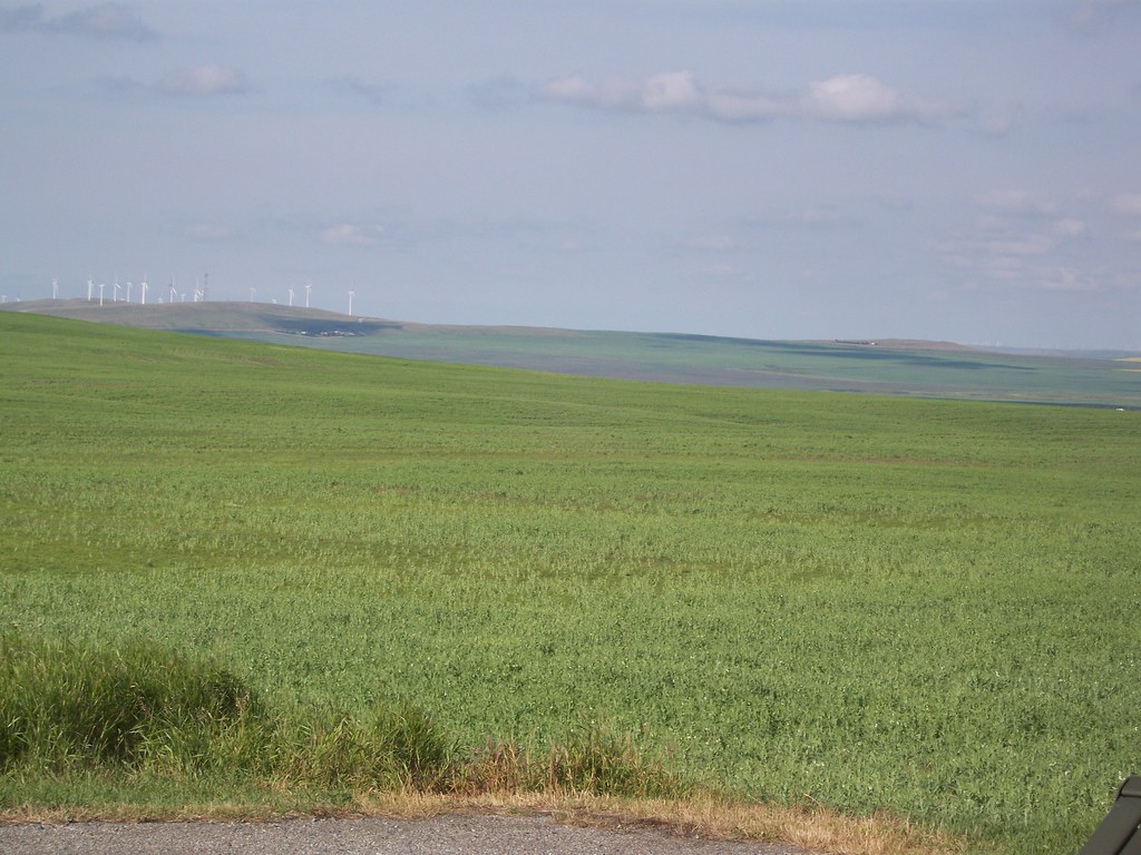
Leaving Waterton we immediately encountered the Prairies. The terrain was still quite rolling, though few hills were particularly steep, and if they were, they weren't that long. So we were afforded great views of the grasslands and ranches in the foreground, and the Rockies in the background, slowly getting further from view. The riding went easy, as there was nothing to really stop for. Twin Butte solely consisted of a combo convenience store/gift shop/Mexican restaurant/Post Office, and it was the only thing between the park and Pincher Creek, a town of 3,000.
Between Twin Butte and Pincher Creek we ran into another couple who were biking southward. They started in Jasper and were heading to Waterton/Glacier and then Kalispell where they'd fly back to Southern California. (Didn't catch their names.) We gave them the skinny about what lied ahead and they warned us about mosquitoes. Great.
And Pincher Creek. Pincher Creek! An actual town! And the first real grocery store we've seen since Whitefish, some 200 or so miles behind us. (If you don't find this exciting, you haven't been on a long bike tour that goes through a whole lotta nothing.) We gleefully stocked up despite the mediocre selection offered. And April found her favorite thing ever: maple-flavo(u)red sandwich cookies that are unintentionally vegan! (Canadians like their maple flavoured items.)
It was less than 15 miles to Lundbreck Falls Provincial Recreation Area, our stop for the night. Not a big deal, except that upon leaving Pincher Creek we noted dark, ominous clouds forming over the mountains to our south. We pushed on as fast as we could (thankfully the terrain was mostly favorable to power riding.) But the clouds started to get closer, and yep, thunder. Great. We managed to dodge most of the storm as the brunt passed behind us, but we did get rained on for the last mile or two to Lundbreck. Overall, a 51 mile day.
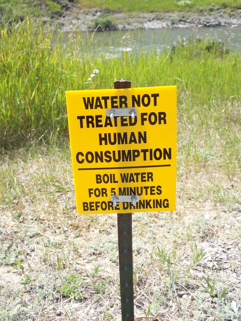
When we arrived at the campground we saw the usual "bear country" signs. But we couldn't find any bear boxes. And the water spigot had a "Do Not Drink Unless You Boil For Five Minutes" sign. Ugh. (All this for $17 a night!) We found the camp host, who couldn't really be bothered. "Oh, I wouldn't worry about bears. Never saw one here." Easy for you to say as you are in an RV. Nevertheless, she offered to store our odorous items, and gave us some water.
Overnight thunder and rain returned and in the morning (Wednesday July 13, Day 48) we were greeted to rain piddling on the tent. We waited inside as long as we could, then just got out to deal with it. Thankfully the rain did let up, and we took a short walk to see the Falls. After what we'd seen in Glacier and Waterton, it wasn't that impressive.
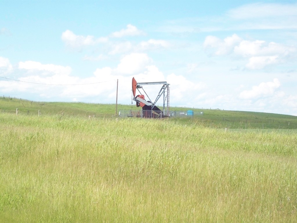
It would be a relatively short day, 47 miles total. But 47 miles of absolutely nothing in the way of services. Which is one reason why we went overboard in Pincher Creek. The route followed Alberta Route 22, part of the Cowboy Trail as the landscape was mostly ranches. The riding was not that hard, though there was a short climb in the beginning and another couple mile climb towards the middle. It was mostly rolling grassland. Traffic was moderate, but there was a decent shoulder. (We've noticed how much better the roads in Alberta are in comparison to Montana. All that oil money!)
It was pretty riding, as we rode between a front range of the Rockies (Livingstone) and a series of low hills (Porcupine). But nothing to stop for, except another camping/picnic spot on the Oldman River (Maycroft Provincial Recreation Area), about 15 miles in, where we broke for lunch. We've rarely taken full lunch breaks as there usually isn't an opportune place to stop, but with no other options for the day, why not? I also made coffee, since there was a water spigot with the "Boil Five Minutes" warning sign available, but another picnicker offered a bottle of water.

The only other remarkable things about the day were the number of cows that we passed (can't even count) and the number of thunderstorms we somehow managed to dodge (two). The camping spot for the night was Chain Lakes Provincial Park. The Chain Lake was actually a reservoir. I don't really find man-made lakes to be that exciting, so I was a bit underwhelmed by the whole experience. The "C" Loop where we camped was nearly abandoned (it didn't have power so all the RVs and the like filled A and B) except for a couple motorcycle touring. We talked with them a bit. Even though they are different things, I can relate with motorcycle tourists more than car campers and SUVs. They can't carry that much, don't go that far in a day (though way further than us bicyclists can), and are also exposed to the elements. The husband also has done some bike touring so we were talking about possible routes as they were from Anacortes, Washington, an area I'm familiar with.
Thursday June 14, Bastille Day. I estimated 60 miles to Calgary, no big deal. And the riding was no big deal as well, the same rolling ranchlands until the town of Longview (a town!) We paused at the Bar-U Ranch National Historic Site, as we were more interested in washrooms and food (which they had) then the history of ranching (us hippie vegetarian bicyclists!) It was still an interesting place to check out. And our first flush toilet since Twin Butte. (Isn't it funny how these things achieve meaning on bike tours?)
Between Chain Lakes and Longview we ran into another touring cyclist heading south to Waterton and then Yellowstone. I was surprised to see another touring cyclist on this road, since the official Adventure Cycling Great Parks Route directs bicyclists to the western (B.C.) side of the divide after Banff. He was surprised as well! We also did pass someone who looked like they were touring outside the town of Black Diamond, but he didn't stop.
While Longview was not much of a town (population 334), it was a demarcation from the lightly settled ranch country we had just passed through and the outer reaches of the Calgary Metropolitan Area which we were approaching. After Longview houses increased and we saw what could be considered one-block suburban neighborhoods scattered in farmlands. Black Diamond was also fairly small (1,900) but it definitely felt like it was becoming a bedroom community for Calgary. The riding was still good in this area, due to the wide shoulders.
This all went to shit when we got to Okotoks. Okotoks is close enough to be considered a suburb of Calgary and it feels it. The nice rural road with wide shoulders abruptly changed to a suburban four lane with no shoulders and plenty of suburban development (Walmart? Sure! McDonalds? Of course!) lining it. And obviously the growth was new and rampant, as signs pointed out "New!" neighborhoods everywhere. It felt like we were in the western suburbs of Portland. But Portland suburbs will at least put bike lanes, here there was none. Not wanting to get buzzed by cars who think that there's enough space for a bicycle and a bike in one lane, I channeled the ghost of John Forester and took the lane. Of course someone yelled "Use the sidewalk", the first time I had heard that epithet since Oak Harbor, Washington. (Has it been really that long?)
 |
| The Okotoks Erratic, a large quartsite boulder left by a glacier |
When we left Okotoks, we got a shoulder, though now the road had turned to pretty much a freeway. I knew that we'd be doing at least a few miles of freeway riding into Calgary, as I couldn't find a suitable alternative. But the thing that made my heart sink was seeing the "Calgary 40km (25 mi)" sign. 40 kilometres? We had already gone 50 and I thought it would be another 10-15 tops. Ugh.
We made do with the few miles of freeway, got into Calgary city limits, and got onto a bike path along the Bow River. At least we'd have a separated bike path for most of the way through town. And it was a beautiful one as well (except for the bugs). The only thing was that it was taking seemingly forever. I watched the miles tick by. The sun was about to set and the skyscrapers of Calgary were still far in the distance. And then we ran into construction on the path, routing us on an awkward detour that caused us to consult the map several times.

Dan, our host for Calgary, grew worried about us. He offered to ride down and meet us somewhere along the path. We finally met up with him near downtown and he guided us the last miles through the dark back to his house on the North side. We finally made it to his abode near 11pm (yeeps!) We logged in 86 miles (138 km), the longest on this tour so far. Exhausted, we ate some food, showered, and hit the sack, sleeping for untold hours.
still alive!
ReplyDeletehttp://www.johnforester.com/
in awe and jealousy of your tour,
Josh G (who rode back from the Gorge w/ you and Fool)
Josh G, next thing you're going to tell me is that Abe Vigoda is alive as well.
ReplyDelete