
Hello friends! There has been a lack of "Portland interest" stuff on this blog, as it has turned into primarily a personal-bicycle type of thing. But the Urban Adventure League's routes, er, roots, are in exploring Portland. This will hopefully become a semi-regular installment. For those of you not interested in these types of things, fear not, I'm sure the next post will be about bikes or something.
-Shawn
I've been interested in the weird nooks and crannies of the Rose City for quite some time. One of the curiosities that I find charming are the "odd streets", thoroughfares that don't make "sense" in the Portland scheme of things. For those who don't grok what I'm saying, let me explain: Portland's street grid is one of the most rational ones in the United States. West-east thoroughfares are named "Streets" and have names to them (example: Burnside St). North-south thoroughfares are "Avenues" and numbered, the numbers getting bigger the further away they are from the Willamette. And everything is divided into a quadrant, with the quadrant at the start of every address (example: 3031 SE Hawthorne Blvd).
But not everything follows these rules. In a few places, someone had the clever idea to place streets at a diagonal to the rigid cardinal direction grid (examples: Ladd's Addition, Woodlawn). Or a geographical feature causes a divergence (examples: Mount Tabor, Alameda Ridge.) Or, it's just too freaking hilly to apply a grid (example: most of the West Hills.)
Or it's North Portland. Yes, North Portland, the "fifth" quadrant. The "streets" and "avenues" rules apply according to direction, but all of the "avenues" are named, meaning navigation is a bit trickier. But because North Portland is a peninsula, the roads tend to follow the contours of the peninsula more than the imaginary grid, so "extra" streets get thrown in the mix.
So "extra" streets aren't always interesting by themselves, but they become more interesting when they get erased from them map. Or, in this case, mostly erased.
*****
Interstate 5 cuts a north-south line through North Portland. The highway, named the Minnesota Freeway for the street it parallels (and in parts, wiped out) cut a trench two blocks wide. Just south of Skidmore Street I-5 bends south-eastwards towards the Rose Quarter, cutting a diagonal instead. It also happens to run along the top of the ridge that overlooks the river. The construction decimated Mississippi Avenue where it climbs the hill; what was once a straight but steep street lined with business between Russel and Fremont is now a winding, empty road. Near the top of the hill sat Revere St. Revere ran from the intersection of Mississippi Ave and Cook St westward towards Interstate Avenue. Much of this was plowed over for both I-5 and the Kaiser hospital.
But this leaves about two blocks worth of Revere, from Missouri Avenue on the west to Mississippi Avenue on the east, that wouldn't be affected by this construction and destruction. And despite much of the neighborhood around it remaining intact even years later, Revere got erased. The street itself torn up, plowed over, overgrown. Why? Would anyone know the answer, these many years later?
Now there are only a few reminders of Revere St. The most prominent one to anyone walking down Mississippi is the pavement marker for Revere on the sidewalk. Portland likes to engrave the name of the street into the sidewalk at the intersection. I love this because it's a great way to find either the old names of streets (the city even goes through the effort to keep the out-of-date name in the sidewalk even when they repave!) or lost streets like Revere. As you can see from the photo, where Revere Street was gets swallowed up into a hillside.
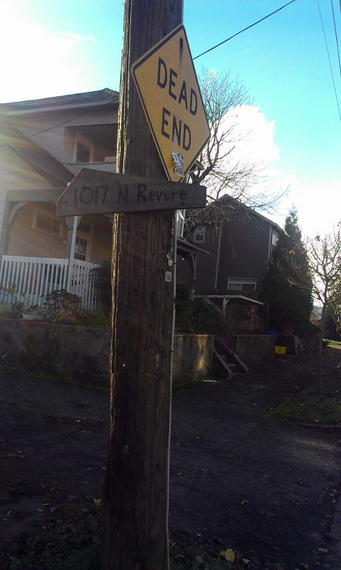
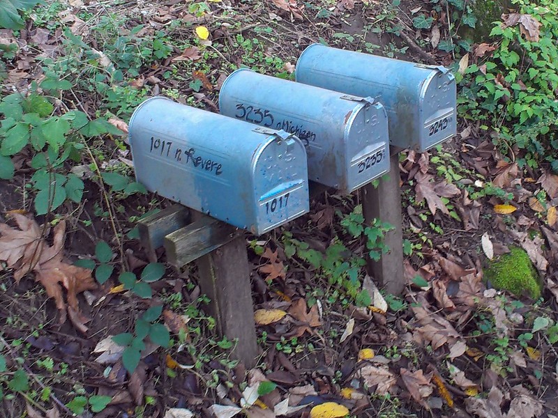
And even though technically the street is "gone", there are still two houses in it. One of which is 1017 N Revere St. This sign on Fremont, pointing down the Michigan-Missouri alley, helps guide one to this off-the-map house. What is left of Revere here is essentially a dirt alley.
The other is 924 N Revere, accessed by the alley between Michigan and Fremont. This house seems to have all the magickal qualities of being on a Street With No Name.

And by this house, a new reminder of Revere in this sign:
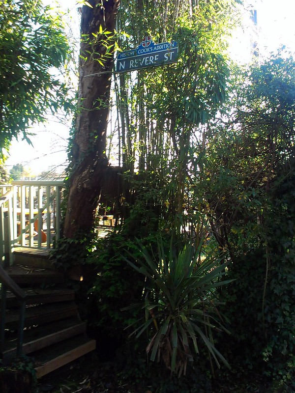
As far as I can tell, this is not an official city sign, but a homebrewed one presumably put up by the owner of this house. Cook's Addition is the historic name of this subdivision.
-Shawn
I've been interested in the weird nooks and crannies of the Rose City for quite some time. One of the curiosities that I find charming are the "odd streets", thoroughfares that don't make "sense" in the Portland scheme of things. For those who don't grok what I'm saying, let me explain: Portland's street grid is one of the most rational ones in the United States. West-east thoroughfares are named "Streets" and have names to them (example: Burnside St). North-south thoroughfares are "Avenues" and numbered, the numbers getting bigger the further away they are from the Willamette. And everything is divided into a quadrant, with the quadrant at the start of every address (example: 3031 SE Hawthorne Blvd).
But not everything follows these rules. In a few places, someone had the clever idea to place streets at a diagonal to the rigid cardinal direction grid (examples: Ladd's Addition, Woodlawn). Or a geographical feature causes a divergence (examples: Mount Tabor, Alameda Ridge.) Or, it's just too freaking hilly to apply a grid (example: most of the West Hills.)
Or it's North Portland. Yes, North Portland, the "fifth" quadrant. The "streets" and "avenues" rules apply according to direction, but all of the "avenues" are named, meaning navigation is a bit trickier. But because North Portland is a peninsula, the roads tend to follow the contours of the peninsula more than the imaginary grid, so "extra" streets get thrown in the mix.
So "extra" streets aren't always interesting by themselves, but they become more interesting when they get erased from them map. Or, in this case, mostly erased.
 |
| A circa 1950 map of North Portland, with Revere St highlighted. Click to embiggen. |
Interstate 5 cuts a north-south line through North Portland. The highway, named the Minnesota Freeway for the street it parallels (and in parts, wiped out) cut a trench two blocks wide. Just south of Skidmore Street I-5 bends south-eastwards towards the Rose Quarter, cutting a diagonal instead. It also happens to run along the top of the ridge that overlooks the river. The construction decimated Mississippi Avenue where it climbs the hill; what was once a straight but steep street lined with business between Russel and Fremont is now a winding, empty road. Near the top of the hill sat Revere St. Revere ran from the intersection of Mississippi Ave and Cook St westward towards Interstate Avenue. Much of this was plowed over for both I-5 and the Kaiser hospital.
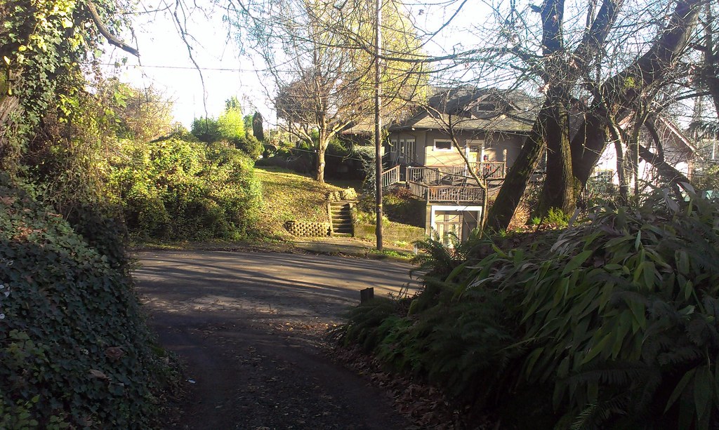 |
| Looking eastward from the Revere-Michigan/Missouri alley intersection. In the foreground is the dirt path that was once Revere. The paved street is N Michigan Ave. On the other side, a brushy overgrown hillside where Revere would continue another block to Mississippi. 924 N Revere is the house behind the house visible in the picture. |
But this leaves about two blocks worth of Revere, from Missouri Avenue on the west to Mississippi Avenue on the east, that wouldn't be affected by this construction and destruction. And despite much of the neighborhood around it remaining intact even years later, Revere got erased. The street itself torn up, plowed over, overgrown. Why? Would anyone know the answer, these many years later?
 |
| From flickr user juliandunn |
Now there are only a few reminders of Revere St. The most prominent one to anyone walking down Mississippi is the pavement marker for Revere on the sidewalk. Portland likes to engrave the name of the street into the sidewalk at the intersection. I love this because it's a great way to find either the old names of streets (the city even goes through the effort to keep the out-of-date name in the sidewalk even when they repave!) or lost streets like Revere. As you can see from the photo, where Revere Street was gets swallowed up into a hillside.
And even though technically the street is "gone", there are still two houses in it. One of which is 1017 N Revere St. This sign on Fremont, pointing down the Michigan-Missouri alley, helps guide one to this off-the-map house. What is left of Revere here is essentially a dirt alley.
The other is 924 N Revere, accessed by the alley between Michigan and Fremont. This house seems to have all the magickal qualities of being on a Street With No Name.
And by this house, a new reminder of Revere in this sign:
As far as I can tell, this is not an official city sign, but a homebrewed one presumably put up by the owner of this house. Cook's Addition is the historic name of this subdivision.
All I know is when I move to Portland I want to live on Revere St. even if Cook's Addition don't add up
ReplyDeletetj
That's some fine detective work. I always enjoy unexpectedly finding old road alignments amidst re-worked infrastructure, but usually I don't find as many clues as you have managed to dig up.
ReplyDeleteWow, this is super cool! Did you see that the Mercury this week has an article, too, on the "off the grid" streets? Honestly, I prefer your post ;)
ReplyDeleteThanks, DeJerk. I saw the Merc piece. I thought it was okay. Wish it was a) longer and b) not just some stuff you can easily find in the "Portland Names and Neighborhoods" book.
DeleteFor those interested, this is what we're talking about:
http://www.portlandmercury.com/portland/off-the-grid/Content?oid=8271672
As the owner of 924 N. Revere St. and the maker of the "homebrewed" Historic Cook's Addition Revere St. sign I have archived the houses and the non-improved Revere St. debacle. When we bought the house in 1999 the 106 Revere St. Albina numbers were still above the front door from 1932. Arnietta Bjornson, who lived in the house in 1925 used to come every Saturday to stand between the two large Douglas Firs on Cook St. 'til about 2001 when she died.
ReplyDeleteDave Edwards
Dave/924NRevere, thanks for the info! Would love to see more of this archived info. (And I deleted the other comment you posted, as it was redundant.)
DeleteAugust Wolden was written in pencil, cursive, lovely hand on the platt blueprint at the Oregon Historical Society over the name James W. Cook in August 1907. He built both 924 N. Revere St. and 3240 N. Michigan the larger was his, 924 the smaller a mother in law house. He, a Norwegian worked as a dock off loader at North Pacific Lumber Co.
ReplyDeleteThe Bjornson family owned 924 in the twenties and operated the Viking Grocery at Fremont and Mississippi, above which was the coffin maker. Bjorn, Lena and their daughter Arnietta all worked at the grocery, now the Sons of Haiti Masonic Lodge. This info from the Polk directories at the Historical Society.
Passionate about historical stuff so any questions I could help.
ReplyDeleteGood to hear. 924NRevere, if you feel like emailing me directly: urbanadventureleague@gmail.com
Delete