
 |
| Beauty Bay from Route 97 |
Hello friends! It's been a little while since the last time I checked in. Currently we are in Missoula, Montana, visiting our friend Heather and having a few break days. We'll probably depart tomorrow and head north to Glacier National Park. We are one month in and we have ridden 1,000 miles! Woo! I'll talk more about that in a separate post.
(This also reminds me that I haven't really filled y'all in with the ride between summitting the Cascades to Spokane. I need to finish that one...
Looking back, it's interesting that it took us the best part of a week to get from Spokane to Missoula. A good part of it was on flattish bike paths, and we only had one mountain pass to get over, and a small one at that. Compare that to the previous week, where we were climbing a pass every day, yet pushing 60 mile days almost every day. Weird.
In my last communique, we had camped for the night in Beauty Creek Campground (United States Forest Service) on Monday night, June 20th. Tuesday the 21st (Day 26 of the Tour) we rode southward along the east side of Coeur D'Alene Lake to connect to the Trail of the Coeur D'Alenes in the small town of Harrison, Idaho (population 200 or so.) The Trail is a former rail line converted to a multi-use path, and the main reason I chose this particular routing through the Idaho Panhandle.
We needed to ride about 25 miles on Idaho Hwy 97 to get to it. At the campground we got "The Warning" from the camp host about the conditions: windy, hilly, traffic, trucks, etc. "Be careful." Being on a bike tour, you will get "The Warning" several times from locals (usually older people) about the impending suckitude of the route you'll be biking. I know there is genuine concern from them, though sometimes the "You are a crazy bicyclist" sentiment comes out a bit stronger than the concern (as it did from the gent in Tonasket, WA who gave me "The Warning" about Route 20.) But in my experience, the actual riding conditions are not nearly as bad as "The Warning" makes it out to be.
And so it was in this case. Hwy 97 started out with a rather large hill. Rather large, though, a 5% grade for about two miles, maybe a 600-700 foot climb total. A practical breeze compared to say Waucaunda Pass. But then the road dropped back down to lake level. The rest of the way into Harrison (with the exception of the other 6-700 foot hill at the other end) was windy with a bit of rolling. But traffic was relatively light, as this was a "byway" and while there were no towns on the way, the whole lakeside was occupied with rather upscale houses and an occasional resort. Most of the traffic was contractor trucks for the houses being built. The scenery was pleasant, but since this was "lake house" territory, there was very little public land on the lake.
We reached Harrison in the mid-afternoon. We ran into the family of bike tourers at the ice cream shop. They had left a little earlier than we did from Beauty Creek, and now were going to head 15 miles west on the Trail of the Coeur d'Alenes to a state park for the night. The park sounded interesting, and it would have been nice to hang out with them some more, but we didn't feel like backtracking. So that was the last we saw of the family.
The rest of Tuesday was on The Trail. The 30 miles of trail riding was some of the easiest and most pleasant riding we've done so far on the trip! The rail trail cruised along the wide flats of the Coeur d'Alene River Valley. Beautiful mountains occupied the distance. Wildlife abounded-we saw many birds like eagles, grebes, and blue herons, deer, turtles trying to cross the path, and we saw a moose (a MOOSE!) drinking on the side of the trail. We almost stopped to take a photo, but moose are unpredictable and we wanted to keep a respectable distance.
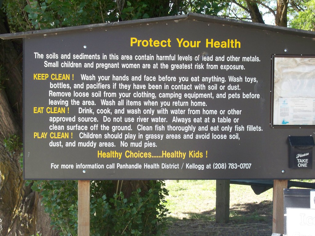
The only downer of the whole experience was the environmental degradation of the area. This is mining country, and there were many lead mines upstream. Everything around the trail contained lead, the soil and the water. The main reason a trail took over the rail line is for environmental remediation. Signs everywhere advised not getting off the path, touching soil, drinking water, etc.
We reached the "town" of Enaville nearing dusk. The trail's website indicated there was camping in Enaville. But all Enaville consisted of was a bar, the Enaville Inn. The inn happened to be hosting a bike bike meet as we arrived, how ironic! We asked the bartender where the camping was in town (as we saw what looked like an RV park from the trail just after crossing a bridge) but she didn't know anything about it. The other bartender told us there was a campground about a half mile up the river. This campground turned out to be an RV park on the riverside. This park wasn't expensive considering how inflated prices can be at these places, but it wasn't cheap either. Oh yeah, there wasn't any potable water, either. Thankfully I figured that out before the caretaker left for the night (he gave me a gallon jug of clean water), otherwise we would have had to boil all of our water first, which is very annoying if you are bike touring. Oh yeah, plenty of mosquitos too. These are the reasons why I tend to avoid commercial campgrounds whenever possible.
The next morning (Wednesday) we didn't really know what we were going to do. We had a Warmshowers host lined up outside of St. Regis, MT, about 80 miles away. It was 20 miles to Wallace, ID, the last place that I knew had services or camping before St. Regis. And it was going to be a hot one, in the mid 80s F. We were already getting loopy from the heat just sitting in camp. So we decided to take a short day and ride as far as we could. This section of the Trail of the Coeur d'Alenes had more towns than the 30 miles we had already done, but it also paralleled I-90, so the riding wasn't as pleasant. We made a pit stop at Kellogg, another old mining town with a weird little downtown. Looks like they were trying to go with a "Swiss Chalet Theme as envisioned through the eyes of the 1950's" to promote tourism in the post-mining era, a la Leavenworth, WA, but were really half-assed about it.
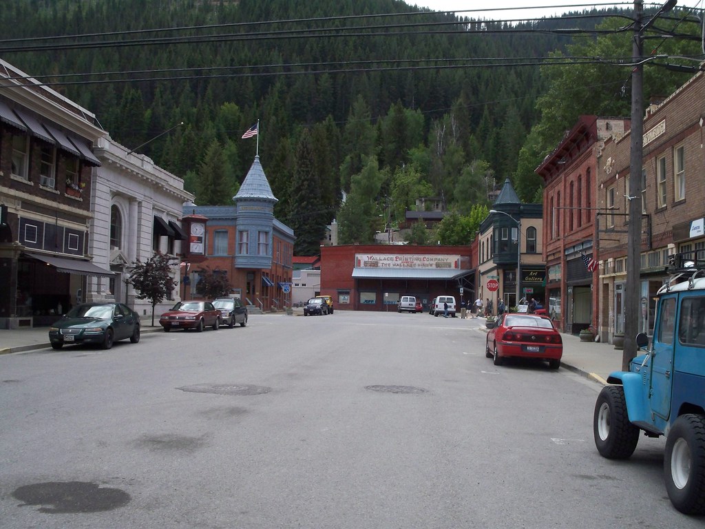 |
| Downtown Wallace |
After lunch and a stop at the bike shop, we continued eastward through the heat to Wallace, where we decided to call it a day after 20 miles. We splurged and got an inexpensive hotel room for the night. We were glad that we decided to stop here, rather than push on for two reasons: Mullan, the next town and "last chance" six miles down the path was depressing and devoid of services (but we wouldn't know that until Thursday) and Wallace was fascinating! Wallace was yet another mining town trying to make do in the 21st Century. But it had history in spades. It had labor disputes and a devastating fire around the turn of the 20th Century. There was a bordello active until 1988 and then preserved into a museum. And my favorite history tidbit: The Last Stoplight on I-90. Wallace was the last mile of non-freeway, surface street routing on Interstate 90, a coast-to-coast highway. It was that way until 1991. Since the valley was narrow at Wallace, the highway department wanted to plow down half of downtown to make space for an at-grade freeway (the cheapest, easiest option.) Wallace didn't want any of this, and to fight it they put every single existing building in downtown on the National Registry of Historic Places. With protected status, the buildings couldn't be torn down. Defeated, they built the freeway on a viaduct on the edge of downtown. Oh yeah, and Wallace is the self-proclaimed "Center of the Universe!" I could go on about Wallace, but it really deserves a separate posting or a more detailed description in "The Book." You can check out what April has to say about Wallace on her blog.
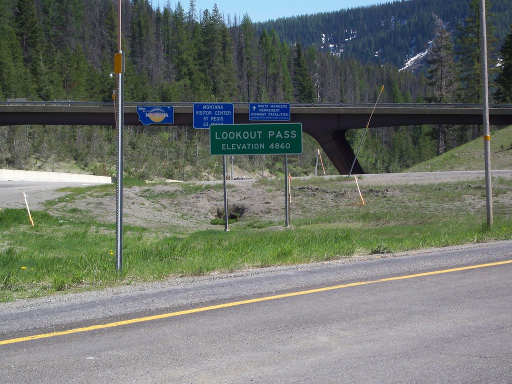
Thursday the weather cooled so we pushed onto St. Regis. We had six more miles of the Trail before it abruptly ended in Mullan, yet another mining town, but one not doing so well. Even though it had roughly the same population as Wallace (900) it had nothing but a couple bars and a gas station/convenience store. From here we needed to summit Lookout Pass to enter into Idaho. We had two options: the old rail grade or I-90. The old rail grade would have been a more gentle ascent (3% grade, tops) but conditions were rumored to be okay to meh, as it had not been paved nor really improved in anyway since they removed the rails. Plus it would be twice as long as taking I-90. So I-90 it was. The shoulder was wide, and the grind up the 6% grade (and 1,400 feet) for about 5 miles took us a little over an hour. And finally we were at the top! Lookout Pass, elevation 4,710 feet. This marked crossing into a new state, Montana, and leaving Pacific Time for Mountain Time. We took a pause at the lodge near the ski area, and got back onto I-90, as the rail grade on this side of the pass was even more iffy than the one on the other side.
The first few miles of the descent was hell. The shoulder was bumpy and littered with sand and gravel. I couldn't safely get up any speed, unless I wanted to take the lane on the Interstate, which is something I did not want to do. Thankfully the situation improved and we got a wide, clean shoulder. The remaining 30 miles into St. Regis were a breeze, as it was a gradual descent for pretty much the whole way. We kept a speed of 20 miles an hour without really trying! And the scenery itself was great as well.
A brief sandwich stop in St. Regis (not really much a town but rather a collection of gas stations, convenience stores, and casinos off the highway) and we rode 9 miles down the Clark Fork River Valley on Montana Route 135 to get to our Warmshowers stay. Jack and Gaynelle live in an actual log house off of the road, and off the grid as well, since the nearest power line is seven miles down the way. So they power their house with solar and generator power. Rustic living, indeed! They were quite the gracious hosts and fed us oatmeal and bananas in the am, great bike touring fuel.
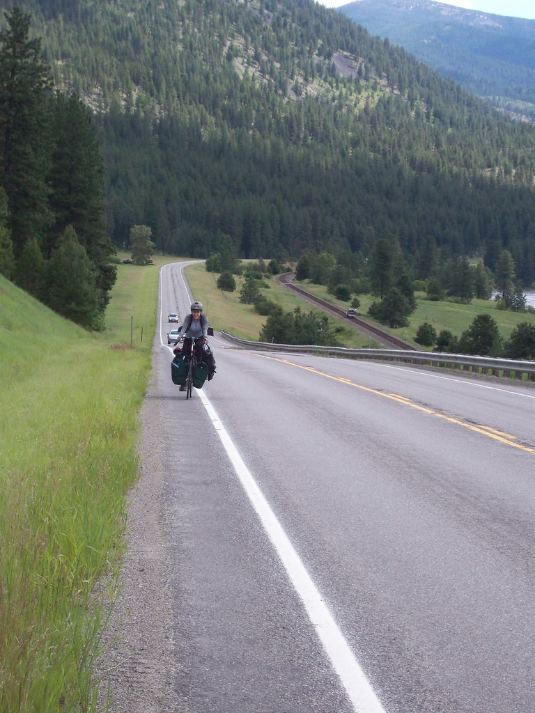 |
| April climbs on Montana Route 135, outside St. Regis |
From the log house it was about 80 miles into Missoula via either the "back" way (Routes 135, 200, and US 93) or the "main" way of I-90. The back way would most likely be quieter (until we hit 93), but there was a dearth of services and camping options. The only one we could find was pretty close to Missoula. We could attempt to free camp at some point, but a lot of the route passed through Reservation which I'm pretty sure would not be kosher. We managed to snag another Warmshowers connection in Alberton, about 50 something miles on the 90 corridor, though the host would not be home and we'd camp in the backyard. That seemed like the best option, so we backtracked the 9 miles to St. Regis, and mostly used roads paralleling the freeway to get to Alberton, though we had to get on 90 for the last fifteen miles. We almost stopped at a public campsite along the Clark Fork River about 15 miles from Alberton. But the river was high (the picinic benches on the river-facing sites were 5 feet or less from the rushing water) and the river was still under a Flood Watch, so we played it safe and pushed onto Alberton.
Alberton was a town of about 400 with a few bars, grocery store, a couple restaurants, and a bookstore. We could feel the pull of Missoula, some 30 miles distant, as we saw signs of "liberal city living"--a woman with a double strollers, new home construction, Subaru wagons with lefty bumper stickers, a bakery playing NPR and prominently displaying a certificate of appreciation from Montana Public Radio. I get the feeling that Alberton is becoming a commute town for Missoula workers as housing prices remain lower in Alberton.
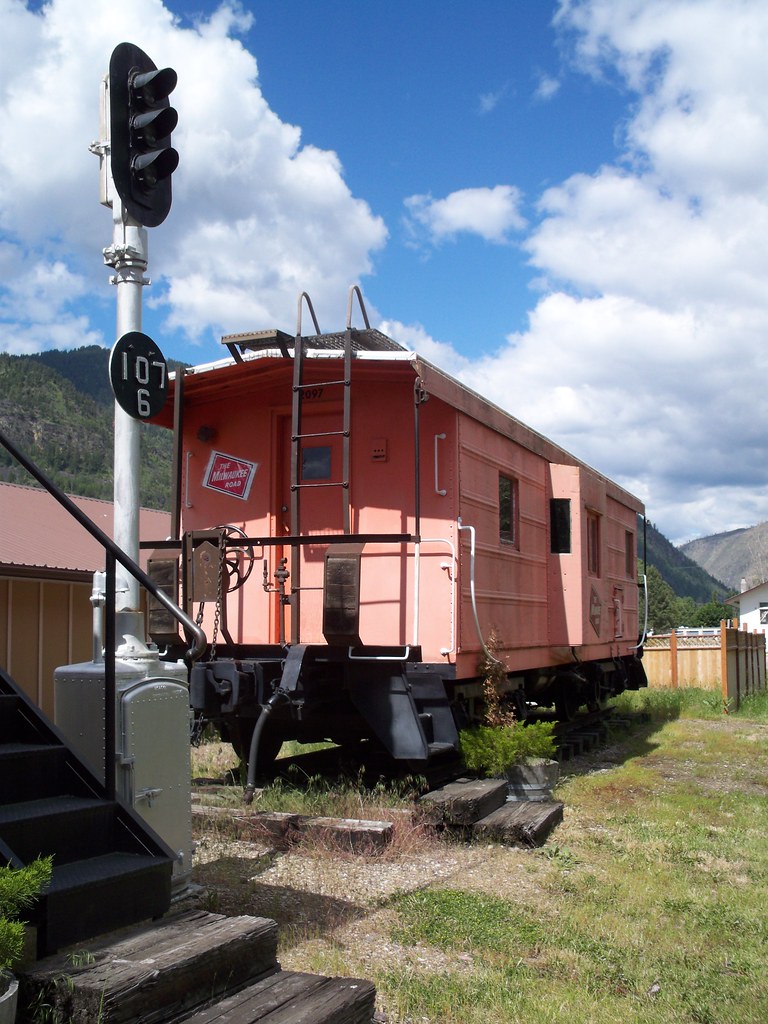 |
| Milwaukee Road caboose, Alberton City Park |
Saturday morning we packed up the tent, made breakfast in the town park, and then rode the remaining 30 miles into Missoula. We had a 10 mile stint on I-90 but the rest was on side roads. Traffic started to pick up and we could see signs of suburban development on the hillsides. We hit mile 1,000 on the industrial outskirts of Missoula. Rather than open up our cheap wine to celebrate, we made it to Big Sky Brewing for complimentary drinks. And then Missoula-Missoula! Finally! College town, natural food markets, assorted hipsters, Adventure Cycling Asssociation headquarters. We ate some food at a burrito joint and made it to our friend Heather's house, where we've been for the last couple days. I'll talk more about Missoula and the 1,000 miles in a subsequent post.
And here's the numbers:
- Day 24, Sunday June 19: Spokane to Otis Orchards, WA: 21.5 miles
- Day 25, Mon June 20: to Beauty Creek Campground (USFS): 32.7 miles
- Day 26, Tues June 21: to campground in Enaville, ID: 58.5 miles
- Day 27, Wed June 22: to Wallace, ID: 21.9 miles
- Day 28, Thurs June 23: to outside St. Regis, MT: 56.3 miles
- Day 29, Fri June 24: to Alberton, MT: 56.6 miles
- Day 30, Sat June 25: to Missoula: 33.3 miles
Distance from Spokane to Missoula: 280.8 miles
TOTAL DISTANCE ON TOUR FROM PORTLAND: 1,010.6 miles!
 |
| We're at Mile 1,000! |
I'm glad everything is going well for you guys. Congratulations on hitting the 1000 mile mark.
ReplyDeleteCongratulations on making 1,000 miles! That is commendable. I remember traveling through that area (albeit by car, alas) and being amazed at all the weird little towns and graveyards and settlements etc. A truly inspiring travelogue you have, sir!
ReplyDeleteGlad you are surviving the bugs. I'm sad to say it is a particularly bad year for mosquitoes in South Alberta (record high rainfalls), though June is typically the wettest and worst month for bugs.
ReplyDeleteSo by the time you head up this way the bug population should hopefully improve. The warmer July weather usually keeps them sleeping during the day.
Fantastic account! This is very exciting and hopefully one day I will be able to make a trip like this. Photos are very nice too; interesting towns.
ReplyDelete